Google Maps input
Use geo-related input types using Google Maps.
Install command
npm i @sanity/google-maps-input@sanity/google-maps-input
What is it?
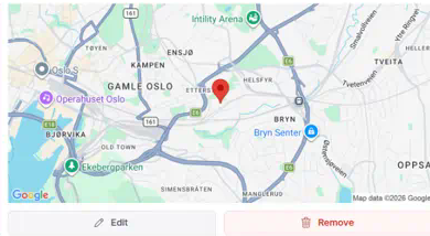
Plugin for Sanity Studio providing input handlers for geo-related input types using Google Maps.
This plugin will replace the default geopoint input component and adds support for geopointRadius fields with circle visualization.
Installation
In your studio folder, run:
npm install --save @sanity/google-maps-inputUsage
Add it as a plugin in sanity.config.ts (or .js), with a valid Google Maps API key:
[!WARNING] This plugin will replace the default
geopointinput component.
import {googleMapsInput} from '@sanity/google-maps-input'

export default defineConfig({
  // ...
  plugins: [
    googleMapsInput({
      apiKey: 'my-api-key',
    }),
  ],
})
Ensure that the key has access to:
- Google Maps JavaScript API (for the interactive map)
- Google Static Maps API (for previewing a location)
- Google Places API (New) (for the search feature)
And that the key allows web-access from the Studio URL(s) you are using the plugin in. If the key is missing or rejected, the input renders an inline message explaining what to fix.
Configuration Options
You can also configure additional options:
import {googleMapsInput} from '@sanity/google-maps-input'

export default defineConfig({
  // ...
  plugins: [
    googleMapsInput({
      apiKey: 'my-api-key',
      defaultZoom: 8,
      defaultRadiusZoom: 15, // zoom level for radius editing
      defaultLocation: {lat: 59.91273, lng: 10.74609},
      defaultRadius: 1000, // for geopointRadius fields
    }),
  ],
})
Field Types
Basic Geopoint Field
// In your schema
export default {
  name: 'location',
  title: 'Location',
  type: 'geopoint',
}
Geopoint Radius Field
// In your schema
export default {
  name: 'serviceArea',
  title: 'Service Area',
  type: 'geopointRadius',
}
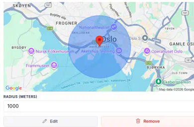
The geopointRadius field type extends the basic geopoint with:
- A radius property (in meters)
- Visual circle overlay on the map
- Editable radius input field
- Draggable circle for radius adjustment
Store selected Zoom
Optionally persists the selected zoom level on the geopoint object.
import {googleMapsInput} from '@sanity/google-maps-input'

export default defineConfig({
  // ...
  plugins: [
    googleMapsInput({
      apiKey: 'my-api-key',
      saveZoom: true, // default false
    }),
  ],
})
Adds a zoom property to the geopoint object:
{
  "_type": "geopoint",
  "lat": 54.5259614,
  "lng": 15.2551187,
  "zoom": 3
}
Reviewing changes
In the document's Review changes pane, geopoint and geopointRadius values render as a before/after static map preview, matching the look of the built-in image diff.
geopointRadius fields get this automatically. Because geopoint is a built-in Sanity type, attach the exported GeopointDiff component to your geopoint fields to opt in:
import {GeopointDiff} from '@sanity/google-maps-input'

// In your schema
export default {
  name: 'location',
  title: 'Location',
  type: 'geopoint',
  components: {diff: GeopointDiff},
}
License
MIT-licensed. See LICENSE.


